DJI Terra: Advanced 3D Reconstruction Software for Precision Aerial Mapping and Modeling
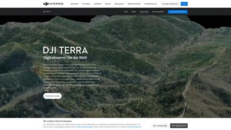
Drone Mapping SoftwareDiscover DJI Terra, the advanced 3D modeling software that integrates photogrammetry with DJI drones. Achieve centimeter-level accuracy for surveying, construction, and more.
About DJI Terra
DJI Terra stands out as an exceptional 3D model reconstruction software that seamlessly integrates advanced photogrammetry technology with DJI's robust drone capabilities. This powerful tool is designed for professionals across various industries, including land surveying, construction, agriculture, and emergency services, making it a versatile asset for any organization looking to enhance its operational efficiency.
One of the most impressive features of DJI Terra is its ability to generate highly accurate 2D and 3D models from aerial imagery. The software's AI-driven optimization for water surfaces and customizable mesh simplification significantly enhances the quality of the output, allowing users to create realistic models and point clouds with remarkable speed. The centimeter-level accuracy achieved in both 2D maps and 3D reconstructions is a game-changer for professionals who rely on precision in their work.
The integration of DJI Terra with DJI Enterprise drones and payloads creates a comprehensive solution that streamlines workflows. The intuitive interface allows users to quickly set up and execute reconstruction missions, while the support for multiple graphics cards ensures that even large datasets can be processed efficiently. This is particularly beneficial for time-sensitive projects where quick decision-making is crucial.
Moreover, the software's capabilities extend beyond basic modeling. The inclusion of LiDAR processing, multispectral data analysis, and real-time mapping features empowers users to conduct detailed inspections and generate valuable insights into vegetation health and infrastructure conditions. The ability to produce various standard formats for easy integration with GIS and CAD applications further enhances its utility across different sectors.
DJI Terra also excels in user experience, offering tools for annotation, measurement, and easy sharing of processed models. The seamless transition to DJI Modify for model editing simplifies the workflow, making it accessible even for those who may not be experts in 3D modeling.
DJI Terra is a groundbreaking solution that not only meets but exceeds the expectations of professionals in the aerial surveying and mapping industries. Its combination of advanced technology, user-friendly design, and comprehensive features makes it an invaluable tool for transforming the way we capture and utilize aerial data. For anyone looking to elevate their operational capabilities, DJI Terra is undoubtedly worth exploring.
Leave a review
User Reviews of DJI Terra
No reviews yet.


